
Expect Snow tonight and into tomorrow morning
Information released
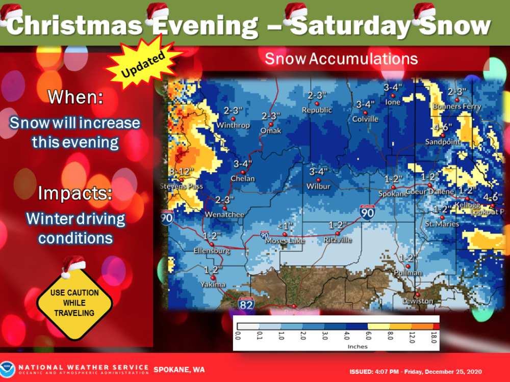
Snow will increase over eastern Washington and the Idaho Panhandle this evening. Most the snow will fall through tonight with many areas seeing snow coming to an end by Saturday morning. Snow showers will continue over the Cascade crest and in the mountains of the Panhandle through Saturday afternoon.
WSDOT has reported that mountain passes, including Stevens Pass (Hwy. 2) and Snoqualmie Pass (I-90) have experienced intermittent closures throughout the day due to spin outs. For current road conditions, dial 5-1-1 or check the WSDOT website.
National Weather Service Winter Snow Advisory, Friday, December 25, 2020 — Snow Tonight into Saturday
Snow will increase this evening over much of north-central and eastern Washington and the Idaho Panhandle. Steady light snow will continue into tonight and then taper off Saturday morning except for showers continuing over the Central Panhandle Mountains into the Saturday afternoon. Snow will result in slippery roads.
Wenatchee Area-Okanogan Valley-Waterville Plateau- Including the following locations Wenatchee, Chelan, Entiat, Cashmere, Number 1 Canyon, Number 2 Canyon, Pangborn Airport, Omak, Okanogan, Brewster, Bridgeport, Oroville, Nespelem, Disautel Pass, Waterville, Mansfield, and Badger Mountain Road…
WINTER WEATHER ADVISORY REMAINS IN EFFECT FROM 4 PM THIS AFTERNOON TO 5 AM PST SATURDAY…
- * WHAT…Snow expected. Total snow accumulations of 2 to 4 inches.
- * WHERE…Wenatchee, Chelan, Entiat, Cashmere, Number 1 Canyon, Number 2 Canyon, Pangborn Airport, Omak, Okanogan, Brewster, Bridgeport, Oroville, Nespelem, Disautel Pass, Waterville, Mansfield, and Badger Mountain Road.
- * WHEN…From 4 PM this afternoon to 5 AM PST Saturday.
- * IMPACTS…Plan on slippery road conditions.
PRECAUTIONARY/PREPAREDNESS ACTIONS… Slow down and use caution while traveling. The latest road conditions for the state you are calling from can be obtained by calling 5 1 1.


