

Crews work to extend fire lines; fire activity reported to be minimal overnight
information released
Yesterday, scattered showers in the early morning provided higher relative humidity across the landscape. Crews were able to go direct along the western perimeter above the Chumstick Creek corridor digging hand line southbound from Forest Road 7801 towards Forest Spur Road 270. Dozers focused efforts to establish a more secure line off Forest Road 52 to connect to Forest Road 717. Scouts were on the ground on Dinkleman Ridge looking for favorable terrain to tie in primary lines to the southeast edge of the fire. Crews attempted to burn along Forest Road 52 in the morning, but conditions were not favorable providing the opportunity to continue to improve Forest Road 52 for future burning operations. Fire activity was minimal overnight.
Today, as primary lines become more established around the fire’s perimeter firefighters look for opportunities to engage closer to the fires edge. Firefighters will continue to hold the fire along the western perimeter in the Chumstick Creek corridor with focus around Second Creek to Forest Road 270. In the north, dozers will continue implementing line along Dry Creek Road while opening old dozer lines from the 2018 Cougar Fire and tie into Gold Ridge connecting dozer line around the entire northwest to northeast flank. With more resources arriving every day, a new division has been implemented in the Entiat River drainage. Crews will be inserted throughout the day.
In the south, crews will continue scouting Dinkleman Ridge from Forest Road 52 down to Miller Canyon to the Entiat Valley floor. Crews continue improving Forest Road 52 and conduct burning operations when conditions allow. Structure crews in the Chumstick and Entiat Drainages continue to assess properties near the fire perimeter. When visibility is favorable, aerial resources are actively engaging in fire suppression. Additional aviation support is expected today with the arrival of 2 UAS (unmanned aerial systems/drones) that have infrared and ignition capabilities.
- Evacuations: Chelan County Emergency Management has lowered evacuation levels from 3 to 2 in the Entiat River Valley around Ardenvoir. Evacuation level 1 and 2 advisories and notices for parts of the fire area are still in place. Please see http://bit.ly/4n63ZZF or https://www.co.chelan.wa.us/emergency-management/pages/active-emergencies for the latest evacuation information. The American Red Cross has set up an evacuation shelter at Warehouse Community Church, 14916 US-97 ALT, Entiat, WA.
- Closures: For firefighter and public safety, the Okanogan-Wenatchee National Forest has put a forest closure in place around the fire: https://www.fs.usda.gov/r06/okanogan-wenatchee/alerts/lower-sugarloaf-fire-area-closure-wenatchee-river-entiat-districts. Check the Okanogan-Wenatchee National Forest’s website Alerts for current closures in the area: https://www.fs.usda.gov/r06/okanogan-wenatchee/alerts.
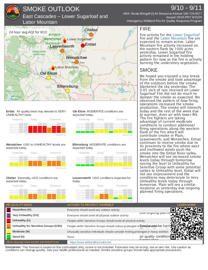
- Smoke: Smoke is visible to the communities of Plain, Leavenworth, Wenatchee, and Entiat. The National Weather Service has issued an Air Quality Alert for the area. Go to WASmokeBlog (https://wasmoke.blogspot.com/) or AirNow (https://www.airnow.gov/) for air quality information.
Fire Stats & Information Resources
- Size: 13,814 acres
- Incident start date: Sept 1, 2025
- Containment: 0%
- Cause: Lightning
- Location: 12 miles northeast of Leavenworth, WA
- Fuels: Timber, brush
- Resources: 17 crews 56 engines 3 helicopters 5 dozers 19 water tenders
- Total personnel: 731
|
Phone: (509) 223-9097
|
||||
|
Email: 2025.lowersugarloaf@firenet.gov
|
||||
|
Inciweb: inciweb.wildfire.gov/incident-information/waowf lower-sugarloaf-fire
|
||||
|
Facebook: facebook.com/LowerSugarloafFire2025
|