Assessment on longer term repair and funding needs is concurrent with road maintenance
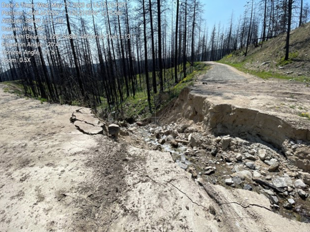
information and photo released by USDA Forest Service, photo: Lambs Butte 5130-300 road showing storm damage at about milepost 4.7 mark on 5/23/23
In early May, a convergence of conditions–including unusually warm temperatures, melting snow from heavy snowpack, and heavy rainfall from spring thunderstorms–caused high water, runoff, and mud and debris, and rockslides that damaged or blocked several national forest roads. In some areas, including fire affected zones, plugged culverts resulted in additional road failures.
Forest Service road-crews continue to assess damage and make short-term road repairs where possible. Assessments are ongoing to help determine long term repair options. Numerous plugged culverts need to be replaced or repaired to prevent additional damage to roadbeds.
For several of these roads there is a need to explore existing and potential funding opportunities to address some of the longer-term repair and restoration needs. There is some funding available to address debris and blocked culvert issues in areas affected by the Cub Creek Fire through a Disaster Relief contract. The Forest will also explore whether any other current contracts could potentially be amended to address some of the culvert work. However, recurring types of damage will require longer term solutions that may potentially include decommissioning and rerouting road segments.
“We encourage visitors to exercise caution and maintain good situational awareness when out on Forest roads, especially when thunderstorms are forecasted,” said Methow Valley Ranger District Recreation Manager Rosemary Seifried. “Check in with the district for the most recent roads information as part of your trip planning and consider what preparedness supplies you might need if you encounter unexpected storm conditions. We suggest carrying extra water, snacks, a shovel, good footwear, and a charged cell phone. It is good to be prepared for the unexpected any time of year that you recreate on the national forest, but particularly important during seasonal melt out due to the unpredictability of rapidly changing conditions.”
“Drivers can also help protect road conditions by avoiding driving on wet and muddy roads to allow time for them dry out,” Seifried added. “Attempting to drive on damaged, wet, or muddy roads can lead to further degradation and expensive repairs and resource damage.” Also, crews recently needed to cut out downed trees that has fallen across roads in several locations; if your capable you may want to carry a chainsaw in your vehicle.
Methow Valley Ranger District Road statuses:
- Finley Canyon Road 4100-300 is open but impassable at milepost 4.5. This section is under assessment to see if it could be made passable with some bulldozer work; long term needs include installing a new culvert and road fill reconstruction.
- Eagle Creek Road 4420 (also known as West Buttermilk) is open and passable but is in poor condition and in need of a culvert, reconditioning, and recontouring.
- West Twisp River Road 4330 is open and passable, however there are numerous plugged culverts that need to be addressed to prevent additional damage to the road.
- War Creek Trailhead/Road 4430-100 is closed at a locked gate and impassable at several debris flow and washed-out road fill locations. Crews are assessing whether bulldozer work could make it passable for the short-term.
- East Chewuch Road 5010 is impassable at the 20-mile ford at milepost 9.0. The gates at the ford are locked shut. Road conditions are rough near Junior Creek at milepost 6.8 and LeRoy Creek at milepost 5.0. These roads are open but not passable by passenger cars. The road needs shaping to make it passable and drainage repair.
- Twentymile Creek Road 5010-700 is open and passable with caution. There is a large boulder blocking half of the travel way. Rock removal will require heavy equipment.
- Junior Creek Road 5010-500 is impassable at milepost 1.9 due to a wash-out. Long-term needs include installing a new culvert and road fill reconstruction.
- First Butte Road 5100-100 is impassable at milepost 4.6 due to a wash-out. Long-term needs include installing a new culvert and road fill reconstruction.
- Eight Mile Road 5130, at milepost 8.0-9.0 is open but impassable to passenger cars due to heavy scouring and rutting near milepost 8.0; it may be passable by four-wheel drive vehicles.
- Lamb Butte Road 5130-300 is closed and impassable as the culverts have blown out at milepost 4.7 and milepost 5.2.
- South Fork Salmon Creek Road 5200 is open but impassable from either end due to heavy scouring, rutting, loss of road fill, and plugged or damaged culverts.
- Harts Pass Road 5400 is impassable, and the gate is closed. There is heavy scouring and rutting in vicinity of Cache Creek. The road needs culverts unplugged and road reconditioning.
Wenatchee River Ranger District Road status:
Wenatchee River Ranger District received reports of road damage in the areas below the Irving Peak Fire and White River Fire burn scars; please note the area fire closure order was recently updated. The area was also under a flash flood alert this past weekend.
Sears Creek 6404 Road: There is a section where water has run down the road, causing heavy rutting and the road prism lost a fair amount of fill slope at milepost 2.8. Crews flagged the embankment that is slightly undermined but still passable. Ruts are also drivable in a pickup.
Naches Ranger District Road status:
Forest Road 1504 is closed at milepost 0.8 due to flood damage and is under assessment. The 1504 Road turns off of the 1500 Bethel Ridge Road and provides access to the Rattlesnake Trailhead and 4WD trail. The damaged section of road 1504 is a location that has recurring natural slump and is closed to vehicle access.


