Winter Weather Advisory Update Includes Stevens and Snoqualmie Passes
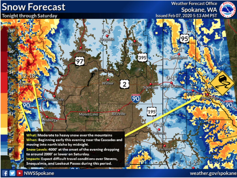
Information and graphics released by National Weather Service – Spokane
A Winter Storm Warning Remains in Effect from 4:00 p.m. this afternoon to 10:00 a.m. (PST) Saturday for the Cascade Crest, including Hwy. 2 between Coles Corner and Stevens Pass, and other areas above 3,000 feet
* WHAT…Heavy snow expected above 3,000 feet. Snow accumulations of 6-10 inches expected on the Cascade Crest including Highway 2 between Coles Corner and Stevens Pass. Also expect winds gusting as high as 55 mph on exposed ridges.
* WHERE…Mazama, Stehekin and Holden Village, Cascade mountains and valleys of Snohomish and King Counties – including Stevens Pass and Snoqualmie Pass.
* WHEN…For the Winter Storm Warning, from 4 PM this afternoon (Friday) to 10 AM PST Saturday.
* IMPACTS…Plan on slippery road conditions. The hazardous conditions may result in very difficult to impossible travel.
* ADDITIONAL DETAILS…Snow will continue at Stevens Pass through mid morning before snow changes to a rain and snow mix. Snow levels will fall this evening impacting more locations including Coles Corner. High avalanche danger expected at all elevations in the Stevens Pass Area with very dangerous conditions near and above treeline elsewhere in the central Cascades.
PRECAUTIONARY/PREPAREDNESS ACTIONS… If you must travel, keep an extra flashlight, food, and water in your vehicle in case of an emergency.
The latest road conditions for the state you are calling from can be obtained by calling 5 1 1. Click on the Mountain Pass Report on wsdot.com


