
Evacuation levels lowered as containment increases
information released by Chelan County Emergency Management
Chelan County Emergency Management reports that all current evacuation levels will be lowered to Level 1 (Get Ready) starting at 8 a.m. Friday. This includes all of South Lakeshore Road, Granite Falls Road and First Creek Road.
South Lakeshore Road at the area just above Fields Point Landing remains only open to property owners due to safety concerns, including guardrail damage and possible falling trees. Field Point Landing is open for drop-offs and pick-ups.
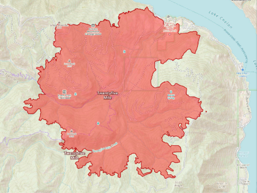
The fire has burned over 11,000 acres and is estimated to be 21 percent contained.
Fire Information Line: 206-659-6472 (Daily from 8 a.m. to 8 p.m.)
Fire Facts
- Size: 11,055 acres
- Total Personnel: 581
- Containment:21%
- Cause: Under investigation
- Structures Threatened: 772
- Structures Lost: 1
Links:
Twentyfive Mile Fire Update: August 26, 2021
Yesterday, crews made significant progress on securing containment lines on the north edge of the fire. Heavy equipment and crews continued to prepare lines to the south near Slide Ridge and were able to initiate a small firing operation in the vicinity of Forest Service Road 8410. Fire behavior was moderate, and the firing operation was successful. Crews maintained an overnight shift reinforcing structure protection operations in and around properties and homes.
Today, fire behavior is expected to increase to moderate or active levels when the cloud cover breaks. Heavy equipment and crews will continue to construct line in areas with heavy fuel loads. Along the southern and western edges of the fire, crews will continue to construct line from 125 to the finger. On the northern perimeter of the fire, crews are continuing to improve the line working south towards Angle Peak while also monitoring and mopping up hot spots around homes and properties.Rotor and fixed-wing air resources will continue working on the fire throughout the day and improved weather conditions make the use of aviation assets more likely today. Aircraft may use local bodies of water, including Lake Chelan. Recreational boaters should be aware of aircraft takeoff and landings and keep a safe distance.The Twentyfive Mile Fire was first reported at 3:45 p.m. on August 15, 2021. The fire was initially burning on the south shore of Lake Chelan near Twentyfive Mile Creek and has expanded south and west of the area. The fire is under joint jurisdiction of the Okanogan-Wenatchee National Forest, Washington Department of Natural Resources, Bureau of Land Management and Chelan County Fire District 7.
Weather: Cloud cover is expected to increase tonight into tomorrow ahead of an approaching cool front. A chance of rain showers will exist over the fire, primarily from Thursday evening through early Friday morning.
Evacuations: The most up-to-date evacuation information is available through Chelan County Emergency Management at the following links. The Chelan County Sheriff will update evacuation levels as conditions warrant.
Evacuation Information – https://www.facebook.com/CCSOEM/
Evacuation Area Maps – https://arcg.is/1iHHmC
Level 3 (Go Now) evacuations for Granite Falls Road and First Creek Road.Level 2 (Get Set) Slide Ridge to the end of the road (up lake).Level 1 (Get Ready) South Lakeshore Road south of Slide Ridge.
Closures: A forest area closure has been issued in the Twentyfive Mile Creek area. Maps of the closure area are available here. All roads in the Level 3 area are closed to the public including Lakeshore Road. Residents are asked to avoid travel on open areas of Lakeshore Road to make way for firefighting personnel and equipment.Smoke Information: Lower temperatures are creating clearer skies; however, smoke and haze may develop later in the afternoon. Visit https://wasmoke.blogspot.com/ for local air quality information.
Fire Restrictions: Campfire restrictions are in effect. Campfires are prohibited throughout the Okanogan-Wenatchee National Forest, including developed campgrounds and congressionally designated Wilderness. Please contact local ranger district offices for more information. https://tinyurl.com/yby4oysq


