
Crescent Mountain Fire Updates
by LakeChelanNow
This story will be updated as new information is received
Crescent Mountain Fire Update from Incident Command: 10:00 a.m., 8/31/18
CRESCENT MOUNTAIN FIRE
Harts Pass Road reopens at Holman Fire
Crescent Mountain Fire: 44,450 acres; 35 percent contained
● Personnel: 625
● Point of Origin: Approximately 21 miles west of Twisp
● Start Date: July 29, 2018
● Cause: Lightning
McLeod Fire: 22,511 acres; 35 percent contained
● Personnel: 458
● Point of Origin: Approximately eight miles north of Mazama
● Start Date: August 11, 2018
● Cause: Lightning
Holman Fire: 297 acres, no containment
● Point of Origin: Holman Peak
● Start Date: August 17, 2018
● Cause: Unknown
Crescent Mountain Fire: Late in the afternoon on Thursday, increased winds and lower humidity levels caused the fire to grow in the Buttermilk Butte area, crossing into the East Fork of Buttermilk Creek near Mission Peak. Crews will be working today to assess and respond to the fire this morning. Fire growth also occurred in the triangle near Kenny Dip, at Scaffold Ridge and West Buttermilk Road. Crews continued to hold and mop-up in the Twisp River corridor. A hotshot crew worked with air operations to cool and hold the fire in the Slate Dip area. Structural assessment teams will continue their work in the Libby Creek area communities today.
McLeod Fire: Crews neared completion of the tactical firing operation tying the fire into the old Diamond Fire burn scar on the north end of 8 mile Road. This work should be completed today. Strategic firing will be used today to complete the protection of Honeymoon and Ruffed Grouse campgrounds. Assessments will be made today of the heat that continues to be an issue on the southwest edge of the fire in the Yellow Jacket Creek area.
Holman Fire: The fire is still actively burning in the Pasayten Wilderness. The Harts Pass road is now open, although there are several trails in the areas that remain closed, including a portion of the Pacific Crest Trail.
Evacuations: Crescent Mountain Fire: A Level 3 (GO now) evacuation is in effect for all persons living west of the Little Bridge Creek intersection in the Twisp River Valley. A Level 2 (get SET) evacuation is in effect for persons living west of Newby Creek Road to Little Bridge Creek Road in the Twisp River Valley. Alerts have been issued for Poorman and Libby Creek. The Red Cross has a shelter available at the Methow Valley Community Center in Twisp. No evacuations are in effect for the McLeod or Holman Fires.
Closures: The Okanogan-Wenatchee National Forest and North Cascades National Park have issued trail and area closures orders in the vicinity of all three fires. Maps and information on the closures can be found on InciWeb. Temporary flight restriction information is available at the Federal Aviation Administration’s website.
Smoke/Weather:
Slight warming and drying is expected over the fires. Temperatures will climb with slightly lower relative humidity. Winds will continue out of the west to northwest during most of the day on the ridges with gusts to 15 mph expected in the afternoon and evening. The Washington Smoke Information’s webpage has information on smoke and public health. Smoke information in Spanish can be found on the WA Dept. of Health’s website.
Crescent Mountain Fire Update from Incident Command: Noon, 8/26/18
Community Meeting at Twisp Community Center, Monday, August 27 at 6:30 p.m.
Favorable weather allowed firefighters to take advantage on several fronts of the fire. Crews were able to go direct on the head of the fire in the Buttermilk Butte area, slowing the spread of the fire. Crews will continue their work in this area to tighten up the perimeter. Further up the Twisp River Road corridor, two heavy helicopters made retardant drops in Slate Dip, an area that has been holding heat for most of the week. Air operations will continue to work in this area today. Crews will also concentrate on mopping up hot spots along the Twisp River corridor. Structural assessment work will continue in the Libby Creek area. No changes to evacuation levels.
This video animation depicts approximate fire location and terrain.
DISCLAIMER: This video graphic shows an approximate perspective of fire activity and the topography of fire location and terrain. It is not an official rendition, and fire incident management have pointed out there are several locater inaccuracies. However, creator Kanji Kato, has provided a dramatic viewpoint that demonstrates the geographical elements firefighters must battle. We are presenting it as an animation example of the general fire vicinity.
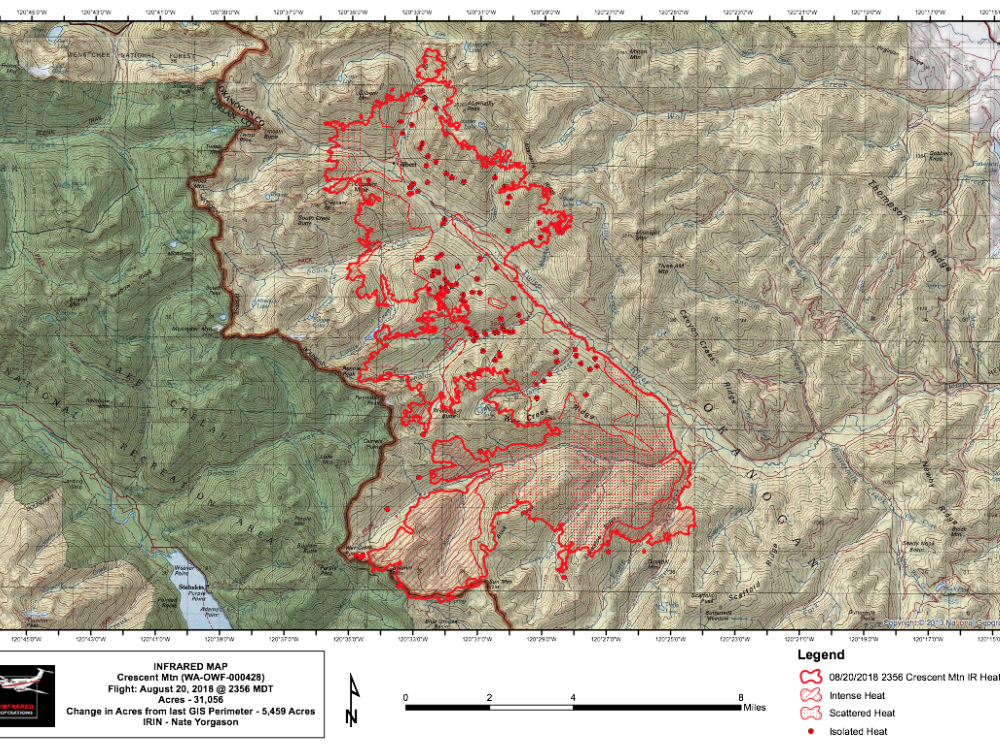
Official information, maps, images and videos come directly from incident command.
Crescent Mountain Fire Update from Incident Command: Noon, 8/23/18
Community Meeting at 6 p.m. tonight in Stehekin at the Community Center
August 23, 2018 @ 8:00 a.m.
Fast Facts:
Crescent Mountain Fire: 36,963 acres; 34 percent contained
- Personnel: 342
- Point of Origin: Approximately 21 miles west of Twisp
- Start Date: July 29, 2018
- Cause: Lightning
McLeod Fire: 17,978 acres; five percent contained
- Personnel: 538
- Point of Origin: Approximately eight miles north of Mazama
- Start Date: August 11, 2018
- Cause: Lightning
Holman Fire: 100 acres, no containment
- Point of Origin: Holman Peak
- Start Date: August 17, 2018
- Cause: Unknown
Current Activity: Due to the heavy smoke in the air yesterday, all aircraft assigned to the Crescent Mountain and McLeod fires were grounded.
Crescent Mountain Fire: Yesterday, the fire progressed southeast towards Duffy Lake, east onto Scaffold Ridge and southwest into North Cascades National Park on Splawn Ridge. Crews continued improving the Buttermilk and Newby Ridge contingency lines. Fire managers are working with the National Park Service to assess protection needs for infrastructure near Lake Chelan. Today will bring critical fire weather so crews are focused on structure protection and holding the fire on Scaffold Ridge, which was treated with fire retardant on Tuesday.
McLeod Fire: Yesterday, the fire spotted across the Sunset Creek so fire crews focused on containing those spots. Crews conducted tactical burning operations around Long Creek and on the west side of Eight Mile road. Today crews will patrol and monitor fire lines while suppressing any spot fires that have breached containment lines.
Holman Fire: This fire is located in the Pasayten Wilderness of the Okanogan-Wenatchee National Forest. There is a forest closure in effect, which includes the Pacific Crest Trail, closed from Hart’s Pass to the Canadian border.
Evacuations: Crescent Mountain Fire: A Level 3 evacuation is in effect for all persons living west of the Little Bridge Creek Intersection in the Twisp River Valley. A Level 3 evacuation means that person should evacuate NOW, do not wait. A LEVEL 2 (BE READY) has been issued for persons living WEST of Newby Creek Road to Little Bridge Creek Road in the Twisp River Valley. The Red Cross has a shelter available at the Methow Valley Community Center in Twisp. No evacuations are in effect for the McLeod or Holman Fires.
Closures: The Okanogan-Wenatchee National Forest has issued several closure orders and a Stage II Fire Restriction. Trail closures are in effect for the North Cascades National Park near Lake Chelan National Recreation Area. See North Cascades National Park website for details. Maps and information on the closures can be found on InciWeb. Temporary flight restriction information is available at the Federal Aviation Administration’s website.
Smoke/Weather: Unstable atmospheric conditions will persist through today, resulting in high fire behavior potential. Smoke impacts should lessen with west winds at 5 mph in the valley and 11 mph on the ridges. The Washington Smoke Information’s webpage has information on smoke and public health. Smoke information in Spanish can be found on the WA Dept. of Health’s website.
Area businesses are open. Please consider showing your support by shopping in the local communities.
Fire Information:
Inciweb: Crescent Mountain: https://inciweb.nwcg.gov/incident/6093/
McLeod: https://inciweb.nwcg.gov/incident/6130/
Facebook: https://www.facebook.com/CrescentMTNFire/
Fire Information Center: (480) 744-9318
Email: gilbertfireinfo2018@gmail.com
Incident Management Team: The Southern Area Blue Type 1 Incident Management Team.
Fire Update from Incident Command, 2:00 p.m., 8/21/18
Level 3 evacuation (GO NOW) has been issued for all persons living West of Little Bridge Creek
- Fast Facts:
- 26,181 acres
- 34% contained
- Personnel: 260
- Point of Origin: Approximately 21 miles west of Twisp
- Start Date: July 29, 2018
- Cause: Lightning
Currently: The Crescent Mountain Fire has crossed Eagle Creek and is advancing east. With the predicted weather the fire is anticipated to increase its movement towards the east.
A LEVEL 3 Evacuation has been issued for all persons living WEST of the Little Bridge Creek Intersection in the Twisp River Valley.
People should evacuate NOW, do not wait. People should evacuate east towards Twisp. The Red Cross has a shelter available at the Methow Valley Community Center in Twisp.
There will be a Community Fire Meeting tonight at the Methow Valley Community Center in Twisp at 6:30 PM
For more information, call the Crescent Mountain Fire information line at (480) 744-9318 or Okanogan County Emergency Management (509) 422-7206


