|
- Bear Mountain area—510 acres near Navarre Coulee, approx. 8 miles west of Chelan, WA.
- Falls Coyote—350 acres on Coyote Ridge, 21 miles northwest of Chelan, WA.
- Washington Creek underburn—200 acres, located 8.5 miles north of Chelan, WA.
- First Creek—135 acres of piles approximately 10 miles west of Chelan, WA.
- Crews will also be burning an assortment of piles that were constructed in the Cooper Ridge area during Pioneer fire suppression activities.
- Smoke from all these burns will be visible from Manson and Chelan.
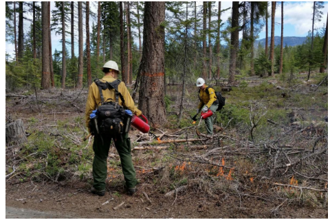
Firefighters use drip torches to ignite debris on the forest floor during a prescribed burn on the Wenatchee River Ranger District in 2019. Credit: USDA Forest Service by Robin DeMario
Methow Valley Ranger District (at total of 2,658 acres of prescribed burning is planned this fall).
- Nickel Canyon underburn—54 acres in the Libby Creek Drainage 5 miles west of Carlton, WA.
- Mission—2,000 acres of hand piles in the Libby Creek area west of Carlton, WA. Smoke will be visible from Carlton, WA.
- Twisp—554 acres of hand piles in the Buttermilk Drainage up Twisp River drainage, 5 miles west of Twisp, WA. Smoke will be visible from Twisp.
- Lost Driveway/Cedar Repair piles—Upper Methow hand piles, 50 acres along State Highway 20 near Mazama, WA. Smoke will be visible from Mazama.
- Crum Canyon—192 acres of underburning located 4 miles northwest of Entiat, WA. Smoke will be visible from Ardenvoir and Entiat. Underburn units include Crum 18, Crum 92, and Crum 82.
- Moe Ridge—75 acres of underburn 2 miles south of Ardenvoir, WA. Smoke will be visible from Entiat, Ardenvoir and possibly Wenatchee.
- Forest Johnson—327 acres of underburn in the EPZ unit located 9 miles northwest of Entiat. Smoke will be visible from Chelan, Manson, and possibly Entiat and Ardenvoir.
- Forest Johnson—478 acres of piles in the Mud Creek area, located 2 miles northeast of Ardenvoir, WA. Smoke will be visible from Chelan, Manson, and possibly Entiat and Ardenvoir. Pile burning units include Bisping 215, Morricle 159, and Morricle 104.
- Tillicum—587 acres of piles in the Yellowjacket 587 unit located 2 miles west of Ardenvoir, WA. Smoke will be visible from Ardenvoir, Entiat, and possibly Leavenworth.
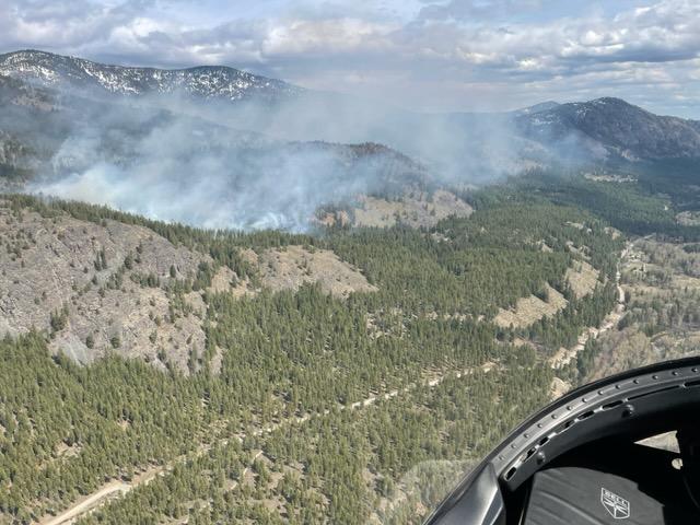
An aerial view of the smoke from the Goat Prescribed Burn on the Methow Valley Ranger District in 2023. Credit: USDA Forest Service by Andy Hart
Cle Elum Ranger District (a total of 577 acres of prescribed pile burning is planned this fall).
- Swauk Pine Legacy Tree Hand Piles—378 acres on the east side of Highway 97, approximately 15 miles northeast of Cle Elum, WA. Smoke may be visible in the Highway 97 corridor and Liberty area.
- Nugget Machine Piles—80 acres on the east side of Highway 97, 20 miles northeast of Cle Elum, WA. Smoke may be visible with in Highway 97 corridor and Liberty area.
- Taneum Machine Piles—84 acres south of I-90, approximately 15 miles southeast of Cle Elum, WA. Smoke may be visible within the surrounding area.
- Walter Springs Piles—35 acres south of I-90, roughly 20 miles southeast of Cle Elum, WA. Smoke may be visible within the surrounding area.
Naches Ranger District (a total of 4,500 acres of prescribed burning is planned this fall).
- Canteen underburn—1,900 acres in the Highway 410 corridor 15 miles northwest of Naches, WA. Smoke will be visible from Naches and surrounding communities.
- Little Naches pile burning—2,600 acres in the Little Naches area 30 miles northwest of Naches, WA. Smoke will be visible in the Little Naches area.
Wenatchee River Ranger District (a total of 2,600 acres of prescribed burning is planned this fall).
- Beehive Units—Plans are to underburn the remaining 179 acres of the project in the Beehive Reservoir area. The units are located approximately 8 miles southwest of Wenatchee, WA and 12 miles south of Cashmere, WA. We encourage people to avoid using Forest Service Road 9712 to the Beehive Reservoir area while prescribed burning occurs. Access along this road may be restricted at times while crews conduct burning operations.
- Martin Ranch Units—588 acres in the Number 2 Canyon/Martin Ranch area located approximately 4.5 miles west of Wenatchee, WA and 7.5 miles south of Cashmere, WA. We encourage people to avoid using Number 2 Canyon Road/Forest Service Road 1701 to the Mission Creek area and the Number 2 Canyon Recreational Area while crews are conducting the prescribed burning. Access along this road may be restricted at times while burning operations occur.
- Mission Maintenance Unit—75 acres in the Blewett Pass area approximately a half mile west of Blewett Pass. We encourage people to avoid using Scotty Creek Road/Forest Service Road 7324 while crews are conducting the prescribed burning. Access along this road may be restricted at times while crews conduct burning operations.
- Hand piles—a total of 1,550 acres of hand piles in three locations: 37 acres on Pole Ridge north of Fish Lake, 1,232 acres along the Blewett Highway corridor near Blewett Pass, and 281 acres between Scotty Creek and Old Blewett Pass.
- 208 acres of machine piles will be burned 4 miles northeast of Peshastin near Derby Canyon.
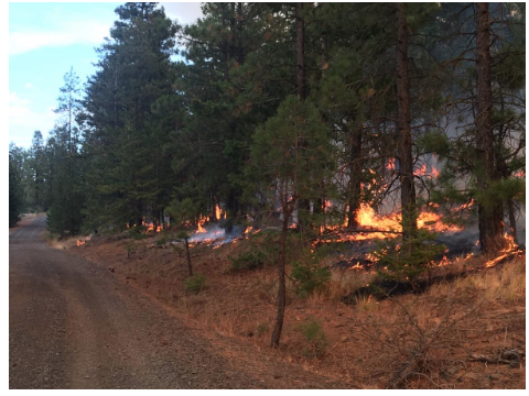
Underburning operations in the Canteen Prescribed Burn Unit on the Naches Ranger District in 2019. Credit: USDA Forest Service by Jason Emhoff
Follow our Facebook and X profiles at https://www.facebook.com/OkaWenNF and https://x.com/OkaWenNF . General forest information can be found at https://www.fs.usda.gov/okawen/.
For more information about these projects, contact the appropriate district office.
- Chelan Ranger District: 509-682-4900
- Cle Elum Ranger District: 509-852-1100
- Entiat Ranger District: 509-784-4700
- Methow Valley Ranger District: 509-996-4000
- Naches Ranger District: 509-653-1401
- Wenatchee River Ranger District: 509-548-2550


