
Class V+ Rapids Provide Whitewater Challenge for an Adventurous Few
by Dennis Rahm, additional information and photos from American Whitewater and Chelan Gorge Recreational Release
A rapid release of water through the Chelan Gorge this weekend will provide an adrenaline rush for a few hardy boaters who dare to challenge the class V turbulence generated through the steep and rocky river gorge.
LCN spoke with Chelan County PUD Park Superintendent Kyle Endelman about this annual recreational release. Endelman oversees PUD parks in Chelan and on the Columbia River above Rocky Reach Dam. He indicated the whitewater event is hosted by Chelan Gorge Recreation Release and American Whitewater.
Eighteen boaters have registered to participate as of mid-week. Endelman expects a few more to register by the weekend. Participants must be 18 years of age and must complete a registration in order to participate.
Participants are coming from as far away as Ontario, Canada as well as from the Washington, Oregon, Montana and Utah. Participants must use non-motorized hard-shelled kayaks or inflatables that are suitable for Class V whitewater.
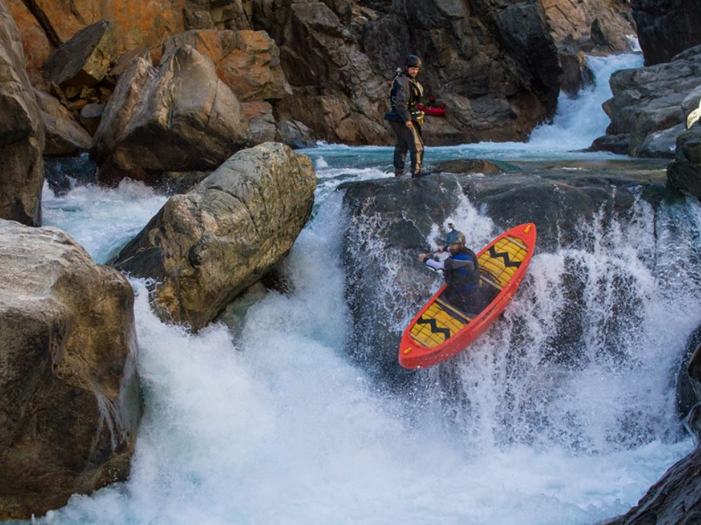
Not for the faint at heart, the short gorge section of the Chelan River — only about 3/10 of a mile long — offers some of the most challenging whitewater boating in the country. The first three miles of the Chelan River are considered Class II, or novice, waters. By the time boaters enter the gorge, it quickly changes into Class V waters challenging “expert” classified boaters.
Endelman advises that it’s not really a great spectator event as public access is limited due to hazardous terrain. He reminds the public to adhere to posted restrictions and to be respectful of landowners by not trespassing on private property. Viewing the end of the run is possible from Powerhouse Park in Chelan Falls. Boating hours are 10 am to 6 pm this Saturday and Sunday.
The Chelan River flow is regulated by the Lake Chelan Dam, which is owned and operated by Chelan County PUD.


Course Description from the American Whitewater website.
IMPORTANT NOTICE: You must sign up with Chelan PUD to take part in scheduled opportunities to paddle this reach.
FUN FACT: Class IV/V in a shorty, in Washington!
PUT-IN: Just below the dam on river-left, an undeveloped road and short trail approach the river. The trail ends on a wide gravel bar that provides a suitable staging area. There are parking and restroom facilities at a nearby City park.
TAKEOUT: There is a developed boat launch at Chelan Falls Park at the confluence of the Chelan and the Columbia. The park also has extensive parking, restrooms, a large picnic shelter, and an extensive lawn for organizing/drying gear.
DESCRIPTION:
Adapted from: Boating Feasibility Assessment prepared for the Chelan Public Utility District by Bo Shelby and Doug Whittaker of Confluence Research Consulting.
The Chelan River begins below the dam operated by the Lake Chelan Hydroelectric project and continues for approximately 4 miles until it joins the tailrace of the powerhouse near the Columbia River. The run can be divided into four distinct sections:
Section 1 is 2.3 miles of class II/III whitewater, and is characterized by a relatively wide flood plain, low gradient (approximately 55 feet/mile), and substrate comprised of large cobble and boulders.
Section 2 is a 0.75 mile long class IV transition zone between the wider floodplain and the Gorge. It is characterized by a narrow channel, canyon walls, moderate gradient (approximately 57 feet/mile), and larger cobble and boulder substrate than Section 1.
Section 3 is “Chelan Gorge,” which is a 0.4 mile long section of class IV and V whitewater, that is further divided into Entrance Exam, Central Gorge, and Lower Gorge. The canyon walls in this section are very steep and narrow, and the gradient of the channel is steep (approximately 480 feet/mile). The channel is characterized by several drops from 5 to 20 feet high, numerous cascades, bedrock chutes, and large, deep pools. The substrate is very large, with some boulders exceeding 20 feet in diameter.
Section 4 is located below the Gorge area and is 0.5 miles of class I water. It is characterized by a wide flood plain, gravel/cobble/boulder substrate, and low gradient (approximately 22 feet/mile). This section extends from the bottom of the Gorge downstream to the confluence of the powerhouse tailrace.
A more detailed descriptions of the whitewater features follows:
Sections 1 and 2
The first three miles feature a swift braided river with occasional islands and riffle areas. At flows up to 500 cfs, the whitewater difficulty in these sections is Class II with a few Class III rapids. Towards the end of this section, at the transition between the braided section and the gorge, the river becomes class IV.
Section 3 – Entrance Exam (Class V)
This rapid has a series of four drops (First Drop, Second Drop, Pile Up, and Final Plunge) in short succession at the start of the Gorge. The rapid is identified by a large rock about 100 feet upstream of a sharp left bend at the mouth of Daybreak Canyon. There is a large pool at the top of the reach where you can scout and portage the entire rapid, as well as a smaller eddy downstream of the first drop where you can also exit the river. Once you commit to the second drop in the series, you have to run the rest of the sequence.
First Drop. This initial challenge is a short waterfall with a strong hydraulic at the bottom. The hole appears weaker in the center, and was weaker at lower flows (273 cfs and 391 cfs). This hole is not the main problem in the rapid, but it requires a clean run because of the drops that lie ahead.
Second Drop/Punch Bowl. The second major challenge in this rapid features a steep, horseshoe-shaped falls immediately above a turbulent re-circulating eddy (the “Punch Bowl”) that extends below an undercut rock. The clean line is just left of a distinct flat rock on river-right; this rock was partially exposed at 391 cfs and nearly dry at 273 cfs.
Pile Up. The third challenge in the rapid is immediately downstream of the Punch Bowl, and features a river-wide hole. This hydraulic is weaker center-right, particularly at lower flows (273 and 391 cfs). At higher flows (475 cfs), this hole becomes a bit sticky, and requires extended effort to clear it. At lower flows, there is a small eddy on river right against the cliff after Pile-up that you can catch but it becomes more unstable at higher flow.
Final Plunge. This last challenge is a sharp drop and hole between two pinching walls; much of the current is directed at the right hand wall, where there is also considerable turbulence. It’s sticky at low and high flow, but cleans up at medium flows of 391 cfs. You can run it after catching the small eddy below Pile-up, and moving strongly from right to left-center. A flat rock in the river is partially exposed at low flow and slows momentum, requiring extended efforts to get clear of the hole. At the high flows, the additional power also requires you to work to clear the hole.
There are scouting and portage options along Entrance Exam from river-right. Those who portage can seal launch into the pool below Final Plunge. There are options for establishing safety along the rapid, particularly below Pile-up and Final Plunge, the two holes where you are more likely to become stuck or have to swim. At higher flows, however, the rock immediately adjacent to the hole in Final Plunge becomes wet and is less suitable (but still usable) for safety efforts.
Section 3 – Central Gorge
A few hundred feet downstream of Entrance Exam are a series of five major rapids in the Central Gorge. Unlike Entrance Exam, each of these are separated by pools with less turbulent water, and each can be scouted or portaged independently.
Double Slide (Class V). The first major rapid in the Central Gorge is “Double Slide,” which features a boulder field and swift currents leading to side-by-side chutes. The river-left slide, referred to as Poser’s Path, is longer, more gradual, and ends in a less turbulent pool. The river-right slide, referred to as Chelan Chute, is more abrupt and concentrated, and ends in turbulence against the mid-channel dividing rock, which is undercut. Both chutes have been run. A short drop and hole, followed by an exposed rock and the right-to-left current, make access to the river-left slide more difficult. Unplanned right side runs occur when you can’t get to the left which then requires last-second recoveries just before the drop. Once in the left slide, it’s easy to bump your way down the shallow channel and into the pool below. The right chute run has a cleaner entrance, but is considerably more powerful and turbulent just above and through the slide. You also tend to make hard contact with the dividing channel wall during right side runs. There are good scouting options for this rapid on the river-right side. The most likely portage route is on river-left well upstream of the entrance into the left hand slide.
Super Boof Falls (Class IV/V). The next rapid is a pour-over falls directly downstream of Double Slide. It’s run by boofing off a rock at the top of the falls on river-left to avoid heavy turbulence at the bottom of the falls. As flows increase, the turbulence also increases, requiring a more precise boof. There are scouting options on both sides of the falls with a possible portage option on river-left.
Throne Falls (Class V). This is another steep drop with strong turbulence at the bottom; the rapid is named for a distinctive throne-shaped boulder downstream of the falls. The falls is generally run right of center. There is heavy turbulence on both the right and left sides of the falls, which increases at higher flows. At the lowest flow, there are some mid-falls rocks, which you can avoid by running further to the right. At higher flow, you may be pushed into the throne, requiring some effort to cross the relatively strong downstream currents and catch the right eddy above Pinnacle Falls. The pool between Throne and Pinnacle Falls is smaller at the highest flow, narrowing the margin of error if you fail to have a clean run. Scouting and portaging options are on river-right. There is a good eddy upstream of the falls. The best portage option appears to be from river-right and ends with a short seal launch.
Pinnacle Falls (Class VI). This falls is immediately downstream of the Throne and is identified by a tall pillar of rock on river-right. The falls is steep and high (probably over 20 feet), concentrating the entire flow of the river through a single slot. The bottom of the falls is very turbulent and although it may be runnable, it was not attempted during the flow release study. There are good scouting options from the river-right eddy above the falls. The portage is “slightly difficult” and involves a short carry over the saddle between the pinnacle and right canyon wall, and then a short seal launch into the pool below.
Boulder Sieve (Portage). The final major rapid in the Central Gorge occurs downstream of Pinnacle Falls, and is identified by several large boulders that act as a sieve in the river. The total drop is about fifteen feet. One good route around this is to ground on a rock on river-left, then seal launch down a partially wetted incline. If one boater gets out to assist others across the rock one can complete the “portage” without getting out of his boat. The ride down the incline on the other side is steep and bumpy, and ends in turbulent water that masks piton rocks. Scouting appears best from the left side. A longer portage to avoid the seal launch may be possible on the left side as well, but may require ropes to bypass larger boulders.
Section 3 – Lower Gorge (Class IV/V)
Downstream of Boulder Sieve, the river becomes less constricted and has a slightly lower gradient. There are several significant drops and boulders in this reach, but the rapids generally have less powerful hydraulics than those upstream. The rapids above the Old Highway Bridge have been collectively labeled “Extra Credit,” while the series of larger boulders and constricted routes downstream of the bridge have been collectively labeled “Fat Lady,” –“it isn’t over until the fat lady sings.”
At lower flows (273 cfs), there are at least two routes in Fat Lady that are very constricted resulting in rock hits as you pass through. The central route, with most of the water, has a sieve with potential pinning hazards. At intermediate flow (391 cfs), there are more route options in both Extra Credit and Fat Lady, but there are still some big rocks to hit. The additional water provides more depth and width in passages, without significantly increasing power in the river. At higher flows (475 cfs), however, while similar routes are available, power in the river increases noticeably and makes some routes more difficult.
In Extra Credit, there is at least one good play hole for rodeo maneuvers and this improves at higher flows. There are numerous opportunities to get out and scout either Extra Credit or Fat Lady from the various boulders, and numerous portage and rescue options are also available if needed.
Section 4
As the river leaves the Gorge, the river offers essentially Class I boating through a braided channel into the outflow channel of the powerhouse as it joins the Columbia. Powerboats and personal watercraft from the Columbia occasionally use the lower end of this reach, as do swimmers from Chelan Falls Park.


