
Nearly 400 acres are slated for prescribed burn in the Lake Chelan Valley
Information and photo released by the U.S. Forest Service
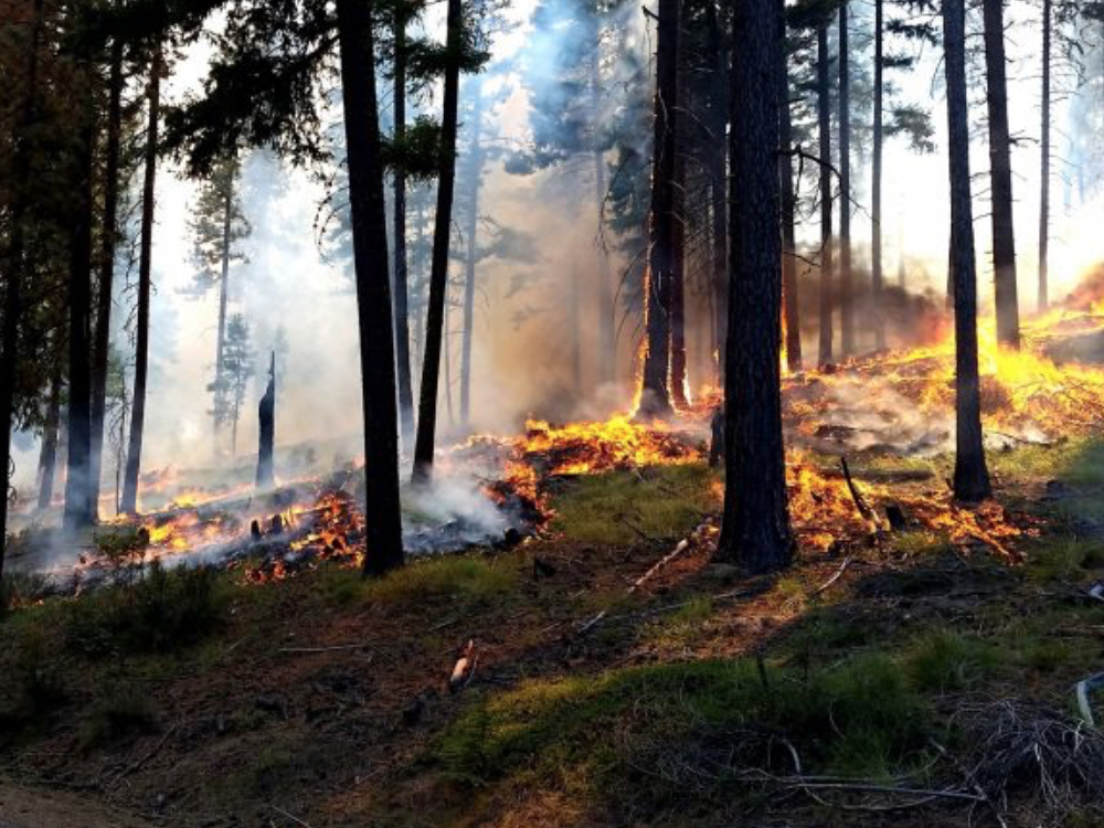
From the Canadian border to south of Yakima, firefighters in Central Washington are planning to burn thousands of acres this fall to increase forest health and protect nearby communities. Excluded from the ecosystem for nearly 100 years, frequent, low-intensity fire is essential for restoring public lands and the communities who depend on them.
“This is a fire forest plain and simple. We should no sooner starve a rain forest of its rain than a fire forest of its fire,” said Forest Fire Management Officer, Rob Allen. “Be to better protected and prepared for when wildfires visit, our communities nestled in this fire forest need frequent, lower intensity fire on nearby public lands.”
While over 11,000 acres are planned this fall, fewer acres may be completed if conditions are not favorable. Conditions include correct temperature, wind, fuel moisture and ventilation for smoke. When these criteria are met, firefighters implement, monitor, and patrol each burn to ensure it meets forest health and public safety goals including air quality.
“While this summer was relatively quiet, there will always be fire and smoke here,” added Allen. “Every acre we burn now is one less acre burning under high-intensity, unsafe, dense smoke conditions in future summers.”
Residents and visitors can expect to see and smell some smoke each day during burning operations. For more information on smoke and public health, please visit: wasmoke.blogspot.com
Real-time prescribed fire maps and updates:
· Facebook: facebook.com/OkaWenNF/
· Twitter: twitter.com/OkaWenNF
· Text message: text ‘follow OkaWenNF’ to 40404 (Apple)
· Interactive map: tinyurl.com/harqnw8
· Phone: 509-996-4040
Fall 2019 priority burn areas:
Chelan County:
• 25 Mile Creek 245ac; 18 miles NW of Chelan, WA
• Forest Mountain 86ac;11 miles W of Chelan, WA
• First Creek/Bear Mountain Piles 591ac; 5-18 miles W of Chelan, WA
• Forest Johnson 1,254ac; 3 miles NE of Ardenvoir, WA
• Switchback Canyon 110ac; 3 miles N of Ardenvoir, WA
• Dill Creek 34ac; 9 miles N of Ardenvoir, WA
• Crum 83ac; 3 miles NW of Entiat, WA
• Moe/Roaring Ridge 128ac; 1 mile SW of Ardenvoir, WA
• Fishpole/Natapoc 550ac; 1 mile SW of Fish Lake, WA
• Upper Peshastin 650ac; Summit of Blewett Pass, HWY 97
• Mission 900ac; 4 miles W of Wenatchee, WA
Okanogan County:
• Bailey 2,688ac; 20 miles SE of Tonasket, WA
• Frosty 141ac; 22 miles E of Tonasket, WA
• Crawfish 250ac; 20 miles SE of Tonasket, WA
• Mutton 1,705ac; 6 miles NW of Conconully, WA
• Lucky 56ac; 6 miles NW of Winthrop, WA
• Upper Rendezvous 210ac; 8 miles NW of Winthrop, WA
• Lost Driveway 611ac; 6 miles W of Mazama, WA
Kittitas County:
• Liberty 100ac; 17 miles NE of Cle Elum, WA
• Orion 300ac; 15 miles NE of Cle Elum, WA
• Teanaway 300ac; 13 miles N of Cle Elum, WA
Yakima County:
• Dry Ridge 200ac; 30 miles W of Yakima, WA near SR410
• Canteen 600ac; 30 miles W of Yakima, WA near Mt. Clemans
*Additional prescribed fires and pile burns may be conducted if favorable conditions allow.
Photo caption: Prescribed fire helps restore the forest and remove unhealthy woody fuel build-up near Naches, WA in 2016 on the Okanogan-Wenatchee National Forest. Credit: USDA Forest Service photo by Jason Emhoff.
