
Smoke may be visible in Central Washington late March through May
information released by Okanogan-Wenatchee National Forest
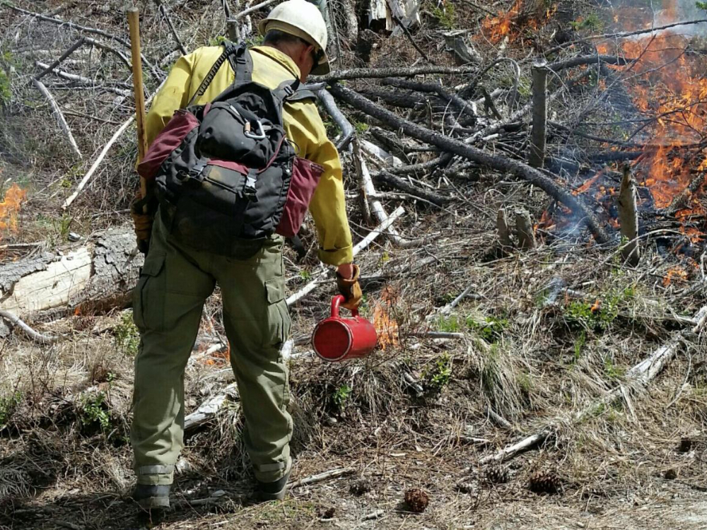
Photo above: A Forest Service employee uses a drip torch to ignite forest debris and dried grasses during a planned prescribed burning project on the Okanogan-Wenatchee National Forest.
This spring, firefighters across Central Washington will once again be putting good fire to work to help restore watersheds and better protect nearby communities. Frequent, low-intensity fire is essential for restoring public lands and the communities who depend on them.
“As the snow recedes, we are gaining access to our spring prescribed fire units. This spring we will be implementing numerous prescribed burns for fire risk reduction and forest health across the National Forest. Depending upon local weather conditions and smoke potential, we will carry out burning when opportunities present themselves to minimize smoke impacts and meet burning objectives,” said Acting Forest Fire Management Officer Matt Castle.
Just over 6,800 acres of prescribed burning is planned this spring, but not all planned acres may be completed if conditions are not favorable. Conditions include correct temperature, wind, fuel moisture, and ventilation for smoke. When these criteria are met, firefighters implement, monitor, and patrol each burn to ensure it meets forest health and public safety goals including air quality.
“These prescribed fire projects reduce the amount of burnable fuels in the forest, improve forest health, and help lower the risk of future high-intensity wildfires,” Castle said.
Residents and visitors can expect to see and smell some smoke during burning operations. Even though smoke from prescribed fire is usually light and doesn’t last long, it is important that smoke-sensitive individuals plan ahead and be prepared. For more information on smoke and public health, please visit wasmoke.blogspot.com or airnow.gov/fires.
For real-time prescribed fire maps and updates:
· Facebook: facebook.com/OkaWenNF/
· Twitter: twitter.com/OkaWenNF
· Interactive map: tinyurl.com/harqnw8
· Phone: 509-996-4040
Late March through May, managed burning operations are planned on national forest lands in the following counties.
Okanogan County:
· If weather conditions allow, crews will be burning piles of forest debris this week in Loup Loup Campground located 10 miles east of Twisp, WA
· Loupy Unit 6 – 73 acres of piles in the Loup Loup Pass area, 10 miles east of Twisp, WA
· Benzer Unit 844 – 10 acres, located 10 miles southeast of Twisp, WA
· Lost Driveway Unit 1 – 141 acres about 3 miles northwest of Mazama, WA
· Lost Driveway Unit 10 – 50 acres adjacent to Highway 20 about a mile west of Mazama, WA
· Lost Driveway Unit 3 – 30 acres and 2.5 miles northwest of Mazama, WA
· Goat Unit 2 – 554 acres, 2.5 miles southeast of Mazama, WA
Chelan County:
· Falls Coyote Unit, 1,269 acres 15 miles west of Chelan, WA
· First Creek Unit, 1,476 acres 10 miles west of Chelan, WA
· FJ Unit, 651 acres, 13 miles west of Chelan, WA
· Crum Unit, 72 acres, 4 miles northwest of Entiat, WA
· Tillicum Unit, 401 acres, 5 miles southwest of Ardenvoir, WA
· The Wenatchee River Ranger District will conduct a small 20-acre training burn in mid to late May, there are no other plans to do prescribed burning on this district this spring
Kittitas County:
· Liberty Unit, 100 acres, 17 miles northeast of Cle Elum, WA
· Orion Unit, 300 acres, 15 miles northeast of Cle Elum, WA
· Teanaway Unit, 500 acres, 13 miles north of Cle Elum, WA
Yakima County:
· Canteen Unit, 1,200 acres, 20 miles northwest of Yakima, WA near Cleman Mountain and Hwy 410
Additional prescribed fires and pile burns may be conducted if favorable conditions allow.


